Our Services

We are Certified by the Kenya Civil Aviation Authority(KCAA) to undertake all services as per our ROC Specification

🌱 Transforming Agriculture with Precision Drone Technology 🚁

At Customized Aviation, we are redefining modern farming through precision agriculture using advanced drone technology to help farmers make smarter, data-driven decisions.

🔍 What we offer:
✔️ High-resolution aerial mapping
✔️ Crop health monitoring (NDVI analysis)
✔️ Precision spraying & fertilizer application
✔️ Field surveying & yield prediction

💡 Why it matters:
Precision agriculture reduces input costs, minimizes environmental impact, and maximizes crop productivity. With real-time insights, farmers can detect issues early, optimize resources, and increase overall efficiency.

🌾 Whether you manage large-scale farms or smallholder operations, our drone solutions give you the edge in modern agriculture.

🎥 Elevate Your Vision with Aerial Filming & Photography 📸

At Customized Aviation, we bring your stories to life from a whole new perspective. Our professional drone services deliver stunning aerial visuals that captivate, inspire, and leave a lasting impression.

🌍 Our Filming & Photography Services:
✔️ Real estate & property showcases
✔️ Events & special occasions coverage
✔️ Corporate and promotional videos
✔️ Tourism & landscape cinematography
✔️ Construction progress documentation

🚁 Why choose us?
We combine cutting-edge drone technology with skilled pilots to ensure high-quality, stable, and cinematic shots, all while maintaining strict safety and regulatory standards.

✨ Whether you’re marketing a property, documenting a project, or creating visual content, we help you stand out with breathtaking aerial imagery.

📩 Partner with Customized Aviation today and capture your world from above.

🗺️ Accurate Insights with GIS Aerial Mapping & Land Surveying 🚁

At Customized Aviation, we provide advanced GIS aerial mapping and land surveying solutions designed to deliver precise, reliable, and actionable data for your projects.

📊 Our Services Include:
✔️ High-resolution orthomosaic mapping
✔️ Topographic surveys & 3D terrain modeling
✔️ Land boundary and site analysis
✔️ Volume calculations (stockpiles, earthworks)
✔️ Infrastructure and construction mapping

💡 Why it matters:
Traditional surveying can be time-consuming and costly. With drone-based GIS mapping, you get faster data collection, enhanced accuracy, and detailed insights, helping you make informed decisions and reduce project risks.

🏗️ Ideal for construction, real estate development, agriculture, mining, and infrastructure planning.

🎯 Stand Out from the Sky with Aerial Advertising 🚁✨

Take your brand visibility to new heights with Customized Aviation’s aerial advertising solutions designed to capture attention both day and night.

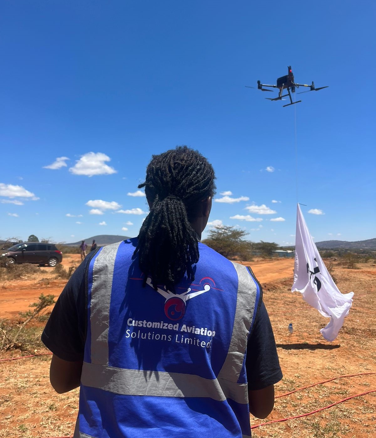
🌤️ Daytime Advertising:
✔️ Drone-mounted banners & flags
✔️ High-visibility brand displays over events and key locations
✔️ Dynamic coverage for promotions, launches, and activations

🌙 Night Advertising with LED Flags:
✔️ Illuminated LED flag displays for maximum visibility
✔️ Eye-catching aerial light branding
✔️ Perfect for concerts, events, and night activations

💡 Why choose aerial advertising?
Your message doesn’t just compete, it dominates the skyline. Aerial campaigns are innovative, memorable, and impossible to ignore, giving your brand a powerful edge.

🚀 Whether it’s a product launch, event promotion, or brand awareness campaign, we help you turn heads and light up the sky.

📩 Partner with Customized Aviation and let your brand fly above the rest.

🔍 Smarter Aerial Inspection & Surveillance Solutions 🚁

At Customized Aviation, we deliver reliable, efficient, and safe aerial inspection and surveillance services using advanced drone technology.

🏗️ Our Capabilities:
✔️ Infrastructure inspection (buildings, towers, pipelines)
✔️ Power line and utility monitoring
✔️ Construction site surveillance & progress tracking
✔️ Security patrols & perimeter monitoring
✔️ Remote and hard-to-access area inspections

💡 Why it matters:
Traditional inspections can be risky, time-consuming, and costly. Our drone solutions provide real-time visuals, enhanced safety, and precise data, reducing downtime while improving decision-making.

🛡️ Ideal for energy, construction, real estate, security, and industrial operations.

📡 Gain visibility. Improve safety. Stay in control.

🌿 Protecting Nature with Drone Technology 🦒🚁

At Customized Aviation, we support wildlife conservation and forestry management through advanced aerial solutions that provide critical insights while minimizing environmental impact.

🌳 Our Services Include:
✔️ Wildlife monitoring & tracking
✔️ Anti-poaching surveillance support
✔️ Forest mapping & canopy analysis
✔️ Habitat assessment & biodiversity monitoring
✔️ Fire detection and environmental monitoring

💡 Why it matters:
Drones enable non-intrusive, real-time data collection, helping conservationists and forestry managers make informed decisions, protect ecosystems, and respond quickly to threats.

🌍 From safeguarding wildlife to managing forest resources, our solutions are designed to promote sustainability and conservation.

Item 1
Item 2
Item 3
Item 4
Item 5
Item 6
Default Title
Default Title
Default Title
Default Title
Default Title
Default Title